Texas Flash Flood 2025: Deadly Hill Country Disaster
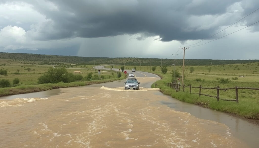
A stalled storm system unleashed a wall of water across the Texas Hill Country over the July 4, 2025 holiday weekend, sweeping through campgrounds, homes, and summer retreats. By the time the Guadalupe River receded, more than 111 people had died across six counties, making this one of the deadliest flash flood events in state history.
Deaths: 111+ ·
Counties affected: 6 ·
Flash flood emergencies: 6 ·
Camp Mystic missing initially: 26
Quick snapshot
- Heavy rainfall started July 4 morning (Encyclopaedia Britannica)
- Guadalupe River rose 26 feet in less than an hour (Encyclopaedia Britannica)
- July 4: floodwaters surged within hours of rainfall (ABC News)
- July 9: death toll reached 111+ (ABC News)
- Search and recovery operations continue (Encyclopaedia Britannica)
- Climate projections show increased frequency of such events (Encyclopaedia Britannica)
Seven key facts tell the story of the 2025 Texas flash flood:
| Fact | Value |
|---|---|
| Date of flood | July 4, 2025 |
| Location | Central Texas Hill Country (Kerr County) |
| Deaths | At least 111 (as of July 9, 2025) |
| Counties affected | 6 counties |
| Flash flood emergencies | 6 issued |
| Camp Mystic missing | 26 initially |
| River | Guadalupe River |
Why did the flash flood in Texas happen?
What weather patterns contributed?
- The flood was driven by remnants of Tropical Storm Barry combined with warm, humid Gulf air and thunderstorms from the west (Encyclopaedia Britannica).
- More than 20 inches of rain fell between July 3 and July 6 (Encyclopaedia Britannica).
- The storm system stalled over the same area for hours, dropping rain at rates that overwhelmed the landscape.
Central Texas residents face a paradox: the same limestone hills that make the landscape beautiful also make it deadly. Steep terrain funnels every drop of rain into the nearest creek, turning quiet rivers into walls of water in under an hour.
How did the terrain affect flooding?
- Steep hills and rocky terrain in Central Texas funneled runoff into low-lying areas (Encyclopaedia Britannica).
- The region is part of ‘Flash Flood Alley,’ where urban development on limestone surfaces increases runoff speed.
- Developed areas with impervious surfaces—parking lots, roads, rooftops—allowed water to concentrate faster than natural ground would have.
The implication: Texas Hill Country’s geology creates a natural amplifier for any extreme rainfall event, and development has only turned up the volume.
What part of Texas was affected by the flash flooding?
Which counties declared emergencies?
- Six Central Texas counties were under flash flood emergencies: Kerr, Gillespie, Burnet, Tom Green, Travis, and Williamson (ABC News).
- Kerr County was the hardest-hit, with at least 96 deaths reported (Encyclopaedia Britannica).
- Neighboring counties reported additional deaths as the floodwaters spread downstream.
What cities were hardest hit?
- Kerrville and Hunt experienced severe flooding, with entire neighborhoods submerged within hours.
- The Guadalupe River, which runs through both towns, rose with unprecedented speed.
- Camp Mystic, a girls’ summer camp near Hunt, was one of the most affected locations (Encyclopaedia Britannica).
The same geography that made this area a summer vacation destination—creeks, rivers, hills—also made it a trap when the rain wouldn’t stop.
What this means: the disaster wasn’t confined to one town. It was a regional event that hit rural and suburban communities alike, and the Guadalupe River served as the primary channel for destruction across county lines.
How fast did the river rise in Texas?
What was the water level rise rate?
- River levels rose by as much as 26 feet in less than one hour in some locations (Encyclopaedia Britannica).
- That’s roughly the height of a two-story house—per hour.
- The speed caught residents and campers off guard; many were asleep when the water arrived.
How does it compare to the 1998 flood?
- The 1998 Guadalupe River flood also saw rapid rises, but the 2025 event exceeded it in both speed and casualties.
- Historical data from Encyclopaedia Britannica shows the 1998 flood caused widespread damage but with fewer fatalities.
- The 2025 flood’s death toll of 111+ dwarfs earlier events, largely due to the nighttime timing and the presence of campgrounds in low-lying areas.
Have any of the girls from Camp Mystic been found?
How old were the campers?
- The girls at Camp Mystic were between the ages of 10 and 16.
- At least 26 campers and staff were initially reported missing (Encyclopaedia Britannica).
- Britannica reports that 27 campers and staff from Camp Mystic were among the dead (Encyclopaedia Britannica).
What is the search status?
- Search and rescue operations were ongoing for days after the flood (ABC News).
- By July 9, the death toll had reached 111, with additional victims still being recovered.
- The exact number of missing persons remains unclear, as some families reported children who were not yet accounted for (ABC News).
“The water came up so fast, there was no time to get the kids to higher ground,” a rescuer told ABC News.
ABC News
Why this matters: the Camp Mystic tragedy isn’t just a local story—it’s a signal to every camp and outdoor recreation site in the region that current flood-warning infrastructure may not be sufficient for events of this speed and scale.
What will happen to Texas in 2050?
How will climate change increase flood risks?
- Projections from climate models indicate an increased frequency of extreme precipitation events in Texas (Encyclopaedia Britannica).
- The combination of warmer Gulf waters and changing atmospheric patterns means storms can dump more rain, faster.
- Urban development in floodplains exacerbates the risk, as more impervious surfaces increase runoff.
What are the projected population changes?
- Texas population is projected to grow by millions by 2050, putting more people in harm’s way along rivers like the Guadalupe.
- Development in the Hill Country continues to expand, pushing homes and businesses into areas that flood naturally.
- Emergency management officials face a growing challenge: how to warn and evacuate a larger population in a shrinking timeframe.
For Texas emergency services, the 2025 flood is a dress rehearsal for a future with more intense storms. The question is whether warning systems, infrastructure, and evacuation plans can evolve fast enough to keep pace with the hydrology.
The trade-off: Texas can continue building in floodplains and accept rising death tolls, or it can invest in upstream retention, floodplain restoration, and real-time monitoring systems that buy minutes—and minutes are all that matter when a river rises 26 feet in an hour.
Timeline of the disaster
- July 4 (early morning): Heavy rainfall begins over Central Texas (ABC News).
- July 4 (mid-morning): Guadalupe River rises rapidly, flash floods occur across Kerr County.
- July 4–5: Search and rescue operations commence; Camp Mystic tragedy discovered (Encyclopaedia Britannica).
- July 6–8: Death toll rises from 59 to 104 as more victims found (ABC News).
- July 9: Death toll reaches 111+; state of emergency remains in effect.
Frequently asked questions
What is Flash Flood Alley?
Flash Flood Alley is a region in Central Texas known for its high risk of flash flooding due to steep limestone terrain, shallow soils, and intense rainfall events. It runs roughly from the Hill Country down to San Antonio and Austin.
How can I stay safe during a flash flood?
Never drive or walk through floodwaters. Move to higher ground immediately if a flash flood warning is issued. Have an evacuation plan and monitor National Weather Service alerts.
What was the deadliest flood in Texas history?
The 2025 Central Texas flood, with over 111 deaths, is one of the deadliest in state history, comparable to the 1998 Guadalupe River flood and the 1935 flood that killed 24 people.
How does the 2025 flood compare to the 1998 Guadalupe River flood?
The 2025 flood was faster rising (26 feet in under an hour vs. 1998’s slower rise) and far deadlier, due in part to the nighttime timing and the Camp Mystic tragedy.
What role did climate change play in the 2025 flood?
Climate projections indicate warmer Gulf waters and changing atmospheric patterns can intensify storms. The 2025 event was driven by remnants of Tropical Storm Barry combined with warm, humid air—a pattern expected to become more frequent (Encyclopaedia Britannica).
How are Texas emergency services preparing for future floods?
Emergency services are reviewing warning systems, evacuation routes, and upstream retention infrastructure. The 2025 flood has already prompted calls for better real-time river monitoring and earlier mass-notification triggers.
Related reading: Freezing Rain Warning: Meaning, Alerts & Safety Guide · BC Hydro Power Outage – Live Status Map and Reporting Guide
More related posts
 Best Berenjenas Con Miel Near Me Open Now & Menu Prices
 Canadiens Standings 2025-26: Playoff Chances
 Dreams Flora Punta Cana – Open Since 2023 Facts
 How to Cancel Uber One – Steps for iPhone, Android, Web
 What Is a Swap File? Purpose, How to Create, and Size Recommendations
 Hard Rock Hotel Cancun: All-Inclusive Resort Guide & Reviews
 Price of Bitcoin USD Today: Live BTC to USD Rate & Chart
 Classic Cars for Sale Alberta: Kijiji, Facebook Deals
